


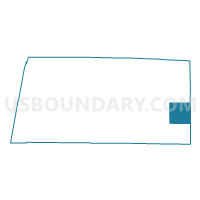
Voting District 1051002000001, Mason County, Michigan
About
Outline

Summary
| Unique Area Identifier | 598219 |
| Name | Voting District 1051002000001 |
| County | Mason County |
| State | Michigan |
| Area (square miles) | 35.99 |
| Land Area (square miles) | 35.41 |
| Water Area (square miles) | 0.58 |
| % of Land Area | 98.39 |
| % of Water Area | 1.61 |
| Latitude of the Internal Point | 43.94684290 |
| Longtitude of the Internal Point | -86.10157430 |
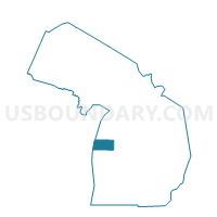
Maps

Graphs
Select a template below for downloading or customizing gragh for Voting District 1051002000001, Mason County, Michigan


Neighbors
Neighoring Voting District (by Name) Neighboring Voting District on the Map
- Voting District 0854432000007, Lake County, MI
- Voting District 0857168000015, Lake County, MI
- Voting District 0857774000016, Lake County, MI
- Voting District 1051944000001, Mason County, MI
- Voting District 1052482000001, Mason County, MI
- Voting District 1054914000001, Mason County, MI
- Voting District 1057306000001, Mason County, MI
- Voting District 1057324000001, Mason County, MI
Top 10 Neighboring County Subdivision (by Population) Neighboring County Subdivision on the Map
- Branch township, Mason County, MI (1,328)
- Custer township, Mason County, MI (1,254)
- Sherman township, Mason County, MI (1,186)
- Sheridan township, Mason County, MI (1,072)
- Lake township, Lake County, MI (862)
- Eden township, Mason County, MI (582)
- Sauble township, Lake County, MI (333)
- Logan township, Mason County, MI (312)
- Sweetwater township, Lake County, MI (245)
Top 10 Neighboring Unified School District (by Population) Neighboring Unified School District on the Map
- Baldwin Community Schools, MI (8,209)
- Mason County Central Schools, MI (7,804)
- Mason County Eastern Schools, MI (3,851)
Top 10 Neighboring State Legislative District Lower Chamber (by Population) Neighboring State Legislative District Lower Chamber on the Map
Top 10 Neighboring State Legislative District Upper Chamber (by Population) Neighboring State Legislative District Upper Chamber on the Map
Top 10 Neighboring 111th Congressional District (by Population) Neighboring 111th Congressional District on the Map
Top 10 Neighboring Census Tract (by Population) Neighboring Census Tract on the Map
- Census Tract 9507, Mason County, MI (3,139)
- Census Tract 9612, Lake County, MI (2,784)
- Census Tract 9601, Lake County, MI (2,300)